The application shows direction you should walk to get the target position like your home, hotel or parked car. Additionally, it says how far your from the target in km/miles/meters and what is your walking/sailing speed in km/miles/knots.
When you lost in forest/mountains or in crowded city, when you travel, climbing or fishing, save your position like parked car, shelter or hotel, and then navigate back following the guiding arrow.

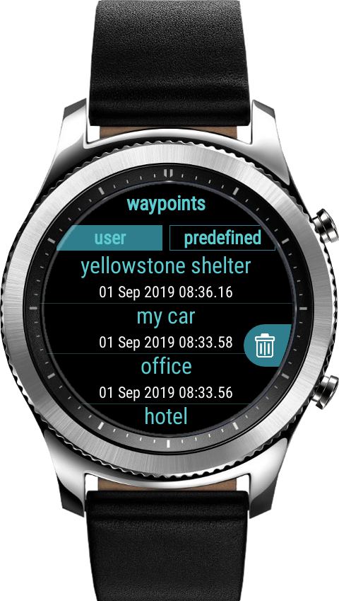


Share waypoints
The application allows to share your target points by Tizen handlers to share files. We recommend to install Filesmaster or Blueft to share files.
Install the app direct from your phone paired with your watch.

How to use?
- Go outdoor. Run the app. Enable GPS/Location in watch settings.
- Wait 1-3 minutes until your watch configure signal from GPS satellites.
- When you see green satellite icon click + icon to add your current position like home, hotel, shelter in mountains or just parked car.
- Now you can exit the app. Your position was saved.
- When you want back to saved position launch the app. Wait for green satellite icon and click left, location icon. From the waypoints list choose a position you want to navigate back.
- The top, white arrow shows you current heading. To get the target/saved position you must much a red point with white, top arrow. The red point is you saved position like home or parked car. You navigate to this point.
- When you heading correct the distance counter is decreased. You are getting closer to your target.
- Click the red point/target to get more details about your target like geographical coordinates or distance to the target.
The application works offline. It doesn’t use Internet connection.
It doesn’t use any maps. You navigate using compass heading.
It is fully standalone app. It uses GPS built-in your watch. You don’t need your phone to use this app.
2 Komentarze
Greg · 18 grudnia, 2020 o 3:24 pm
Does this app show the north like a magnetic compass?
Admin · 18 grudnia, 2020 o 3:27 pm
Yes, it does.
Możliwość dodawania komentarzy nie jest dostępna.